Using Drones for Crop Loss Claim Evaluation

The traditional crop insurance and claims process is costly, time-consuming, and sometimes contentious. Valuable customer relations depend on trust. Trust that the insured feels they will be treated fairly. A claims process that is based on quantifiable, transparent, and easily understood data helps to ensure a sense of trust in the process, and in the relationship.
It is challenging to produce an accurate assessment of damage with traditional scouting methods from the ground. Compounding the difficulty, weather events can overwhelm insurance companies with claims. When a loss occurs, the time spent scouting the fields can be significant. Weather events result in a need to maximize the number of fields and clients visited in a day while maintaining a fair and accurate analysis.
All parties involved require assessments that are fast, fair, and accurate as opposed to slow and imprecise. Using drones to survey crops as part of the claims process results in increased accuracy, efficiency, safety, time savings, and improved customer relations. The evaluation is faster and more accurate, as well as easier to do and better documented.
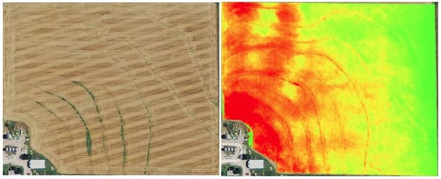
The quality of crop assessment drone data is such that not only can damaged areas be precisely identified, but the type and degree of that damage can also be quantified as well. With the use of specially designed agricultural multispectral cameras, drones can provide a complete plant health analysis of the surveyed field. This multispectral plant health analysis is accomplished with the creation of a drone generated NDVI map of the affected field.
“NDVI or Normalized Difference Vegetation Index is a measurement of the amount of live vegetation in an area and is commonly used for agricultural assessment. The basic principle of NDVI relies on the fact that, due to their porous layers found on their backsides, leaves reflect a lot of light in the near-infrared, in stark contrast with most non-plant objects. When the plant becomes dehydrated or stressed, the spongy layer collapses and the leaves reflect less NIR light, but the same amount in the visible range. Thus, mathematically combining these two signals can help differentiate plant from non-plant and healthy plant from a sickly plant.” Source - https://www.flamanagriculture.com/blogs/417
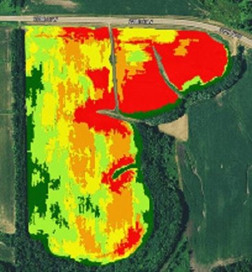
The results of the drone NDVI map can be easily visualized. The aerial data images can be zoned and annotated according to plant health. After a quick look at the NDVI map, areas of the field that need immediate attention can be determined quickly, scouting of the field can be targeted, and samples gathered. The days of random samples and standing on tailgates to get a view of the field are a thing of the past.
All measurements of the affected areas and plant counts can easily be quantified with options for automatic pdf reporting of results. Advanced image analysis techniques and machine learning algorithms are helping further automate the claims process as well as increase objectivity. After the initial assessment, the digital data acquired can be easily shared with all stakeholders. This data also provides the farmer with actionable information that can be used to help maximize the crop output based on current conditions.
With assistance from drone service providers, claims adjusters can process more claims more accurately. Insurers utilizing multispectral drones have found that the efficient workflow and easily understood data leads to significant savings and better customer relations.