The Ways of Wind: Storm-Related Damage, A Forensic Engineering Overview

First, an Introduction from South Florida's Forensic Engineer: Sergio Arratia
One of the key areas of concern in the South Florida region is around storm-related wind and water damage to architectural and structural building components. With this in mind, I am pleased to share this article from my colleague that explores EDT's approach to determining cause and evaluating the scope of wind damage through our investigations.
___________________________________________________________________________
The Ways of Wind
By: Nicholas K. Pontillo, P.E.
As most of us realize, the predominance of storm-related damage is attributable to wind. In this regard, wind storms often generate a two-part question for those involved with root cause investigations:
- What was the maximum wind speed at the location of interest?
- Why was damage sustained if the prevailing building code required the building and building components to resist winds greater than the maximum recorded wind speeds?
Wind Speed Data
The determination of maximum wind speed at a given location often requires some interpretation given that weather stations are usually located some distance from a point of interest. Meteorological stations which measure and record wind data are identified and located in one of three ways:
- Station index number – assigned by the World Meteorological Organization (WMO)
- Location indicator – assigned by the International Civil Aviation Organization (four letter indicators)
- Location indicator – assigned by the U.S. Federal Aviation Administration (three letter indicators)
The National Centers for Environmental Information's website provides a means by which to identify a station by index number or location indicators (https://www.ncdc.noaa.gov/data-access/land-based-station-data/station-metadata). For example, the index number for the station at the Kansas City International Airport is 724460. In Omaha, the Eppley Airfield location indicator is KOMA.
Websites that provide free historical wind-related station information include the following:
- www.wunderground.com/history (enter a location and date)
- https://www.ncdc.noaa.gov/cdo-web/datatools/lcd (enter a location and date)
- www.spc.noaa.gov/climo/online/ (enter a date)
For a fee, meteorological consulting firms can provide quantifiable, site-specific historical weather reports within a reasonable degree of meteorological certainty.
Design Wind Speeds
From a building design perspective, and over the years, maps showing basic wind speeds have been published by the American Society of Civil Engineers (ASCE) in the document entitled “Minimum Design Loads for Buildings and Other Structures.” The most recent edition, ASCE 7-16, was published in 2017.
Prior to 1995, wind speeds shown on the ASCE maps were based upon the “fastest-mile wind speed.” Fastest-mile wind speeds were obtained from anemometers and represented an average of wind data for the time it took the fastest mile of wind to pass the weather station. For a fastest-mile wind speed of 60 miles per hour, interpretation of the wind data would show that one mile of wind passed the anemometer in one minute.
After 1995, and since the National Weather Service discontinued the use of the fastest-mile wind speed, wind speed maps published by ASCE use a 3-second gust speed at 33 feet (10 meters) above the ground. A 3-second gust represents the peak wind gust associated with an average time of 3 seconds. The wind speed maps shown in ASCE 7-16 are based on a 3-second gust with a varying recurrence intervals.
Did Wind Do This?
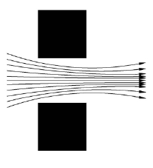
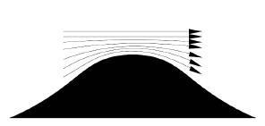
Buildings and building components can sustain wind-related damage even though the recorded 3-second gust experienced by the building is less than the building’s design wind speed. An example of why a wind speed less than the design wind can result in damage is channeling. Channeling is the result of wind that passes through clusters of elevated structures, such as clusters of buildings. Similar to channeling, wind speeds can also increase due to topographical features. For instance, as wind approaches a hill, low-level air is forced upward resulting in a higher wind speeds near the top of the hill. Another such condition is vortex shedding. Vortex shedding creates a problem when the formation of vortices results in repeated fluctuations of a building or structure. A common example to illustrate vortex shedding is the vibration of a stop sign during high winds. Other factors which can contribute to wind-related damage include defective design, poor quality building materials, and/or improper installation.

Download this article as a PDF:
About the Engineers
Mr. Pontillo is a Civil/Structural Consulting Engineer & District Engineering Manager in our Kansas City office. He provides structural evaluation and damage assessment of commercial and residential buildings and structures.
Mr. Arratia is a Civil/Structural Consulting Engineer in our new South Florida forensic engineering office.
Mr. Arratia provides consultation related to construction evaluation of residential and commercial structures, failure analysis, evaluation of scope and cause of damage to structures, wind and hail damage assessment, water intrusion investigation, remediation analysis, structural load analysis, and structural design analysis.